The St Christopher Greek church, Pistofanton (Abay 2023:114).
The Early History and the Greek Churches of Santa, Pontos
Sam Topalidis (2024)
Pontic Historian
Introduction
Santa (pronounced Sunta in Greek, Turkish Dumanli) with its seven main nucleated districts between 1500 m and 1800 m elevation, is located around 70 km by road south of Trabzon (Fig. 1). According to Hionides (1996: 206–207), these Greek districts were located close to each other—within a 15–30 minute walk. Six of the districts, Ishananton (Turkish Işhanli), Kozlaranton (Cinganli), Pinatanton (Binatli), Pistofanton (Piştoflu), Terzanton (Terzili) and Tsakalanton (Çakali), are located on the western slopes. On the opposite slope is the district of Zournatsanton (Zurnaçili) (Fig. 2). Besides these seven main districts there were the following districts around Santa: Alainton, Ftelen, Garakotil, Haratsanton, Kopalanton (Goballi in Turkish with the Greek church St Haralambos) and Ypapanti. (The first five are located in the south-east corner of the Greek map at Fig. 3.)
Santa is located at the end of the Yanbolu valley, at an isolated point of the Pontic mountains. The roads to Santa are impassable during the colder months. In each of the main districts there are churches, houses and fountains made of stone. (Eastern Black Sea Development Agency 2016:24).
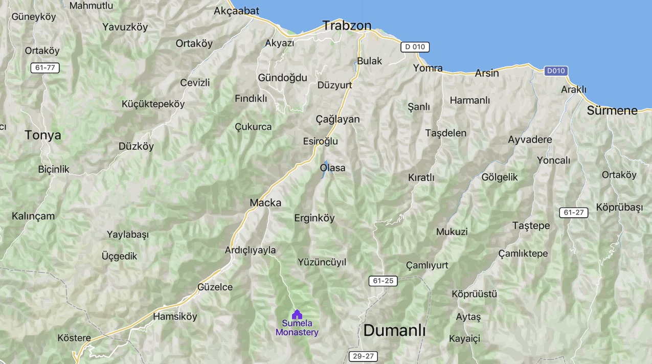
Fig. 1: Location map of Santa (Dumanli, in Turkish, scale: Trabzon to Sumela monastery = 36 km, https://mapcarta.com/13841388/Map).
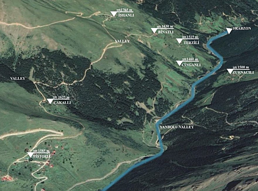
Fig. 2: The seven main districts of Santa (in Turkish, Google Earth, modified by Abay 2023:63).
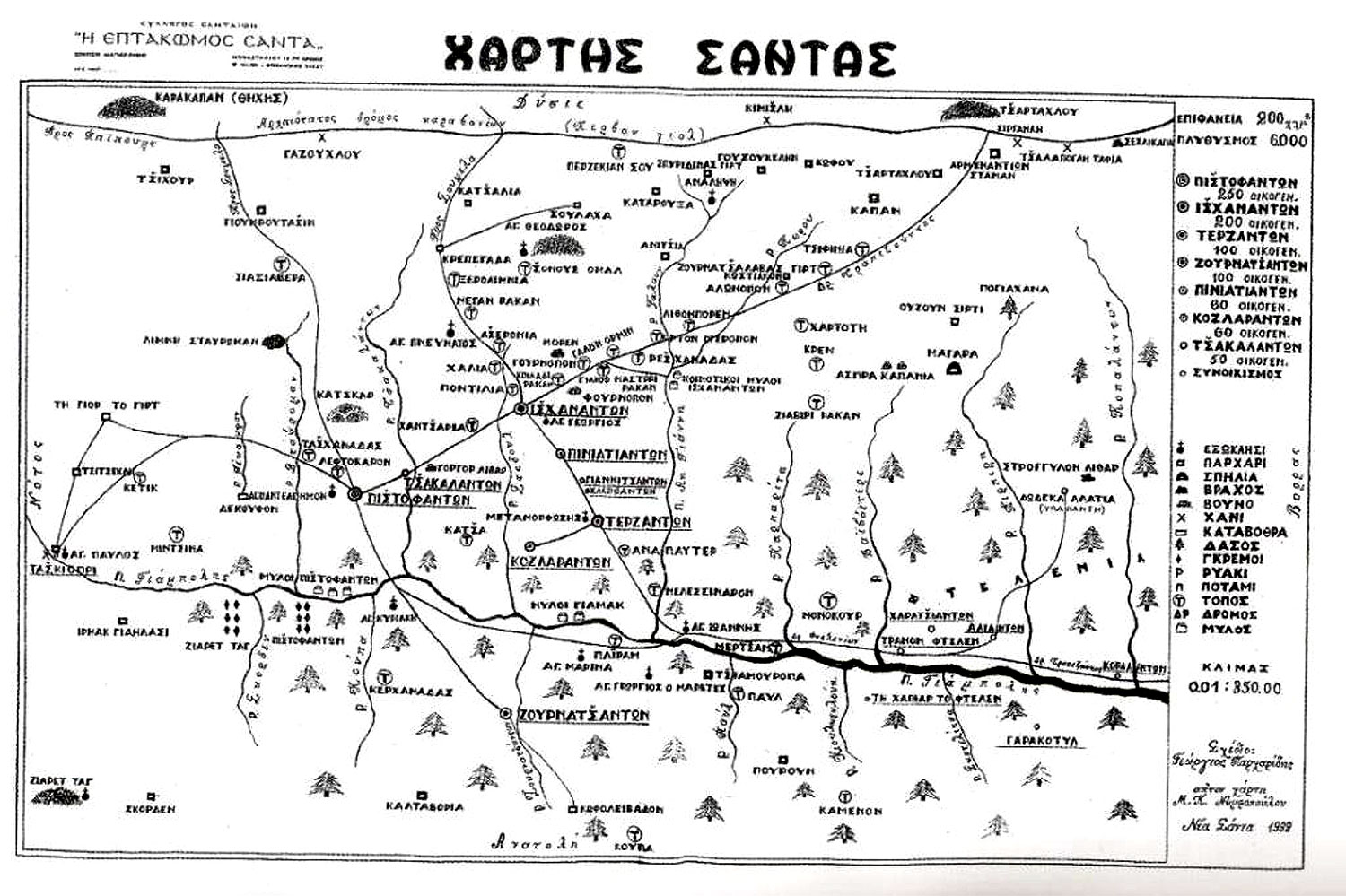
Fig. 3: Santa map (in Greek,
History of Santa up to 1914
There is no physical evidence of a medieval settlement in Santa or along the entire Yanbolu valley (Bryer and Winfield 1985). Santa is officially mentioned for the first time in the 1554 cadastral book of Trabzon (Abay 2023). It seems that its population only began to expand in the 17th and 18th centuries, when it became a semi-autonomous Greek refuge during the derebey [feudal valley lords1] troubles. From the 1680s, the marginal lands along the Tsite valley, south-west of Torul and in the Kromni, Imera, Stavri and Santa districts were settled, apparently for the first time, by Greek Christians and crypto-Christians who were miners, smelters, [tree-fellers and] charcoal-burners and graziers. The Santa districts lie on high marginal land between the tree line and the summer pastures [parharia] within the Greek metropolitanate of Rodopolis (established in 1860, which included the three great Greek monasteries of Soumela, Peristereota and Vazelon)2. From the 18th century, the Santalis created one of the most remarkable and renowned local Pontic Greek cultures (Bryer 1968, Bryer and Winfield 1985).3
Santa was easily defended to the north in the ravines through which the Yanbolu river runs. The Santali were famed for their independence and fighting spirit (Bryer 1968:108–109). Due to the metalworking [including mining and smelting] of its inhabitants and the services they provided, Santa gained the status of semi-autonomy in 1725 (Bruneau (1995) in Abay (2023:65)).
The naturally isolated position of Santa helped the Greek inhabitants to preserve their culture. Each district had its own council which solved its own problems. There was also an assembly of the chiefs of each district (Athanasiadis (1967) in Abay (2023:78)).
In the count of crypto-Christian4 families, which Stevens, the acting British consul at Trabzon reported in 1857 (rounded to the nearest five families in Table 1), Santa appears as the only area in the Pontic mountains which ‘apparently’ had no Muslim residents with 59% of them Greek and 41% crypto-Christian. Bryer (1968) could not understand the necessity for secret Christianity in an area which had no Muslims and tentatively suggested that the crypto-Christians may once have been Muslims who, because of the majority of Christians who surrounded them, were in the process of becoming Christians. By the end of the 19th century, however, Santa was inhabited entirely by [Romeyka] Greek-speaking Christians.5 Importantly, it was noted that in 1879 the Santalis kept guns, like Muslims. Stevens ‘estimated’ population figures (an estimate of five members per household can be used). Thus, in 1857, there were about 3,075 Santalis (in 1898 there was believed to be over 5,000 Santalis, see Table 2) (Bryer 1968:111–114, 129).
In his 1857 letter [after the mines had closed], Stevens stated that the adult men from Santa were chiefly stone masons, stone-putters, bricklayers and builders and the Greek families also produced dairy goods. Their pasture had been contested by a nearby Turkish village (Bryer 1983:42–43). In 1860, the task of renovating the Soumela monastery was given to the stone masons of Santa (Abay 2023).
Table 1: Ethnicity of people in in Santa districts, 1857.
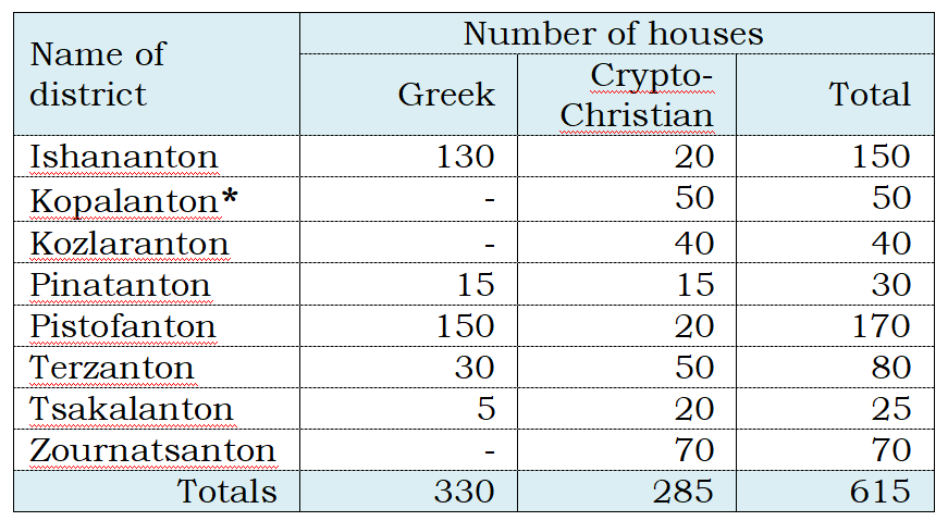
Source: Bryer (1983:39). *Not considered one of the seven main districts of Santa.
Table 2: Number of houses, schools and students in Santa districts, 1898.
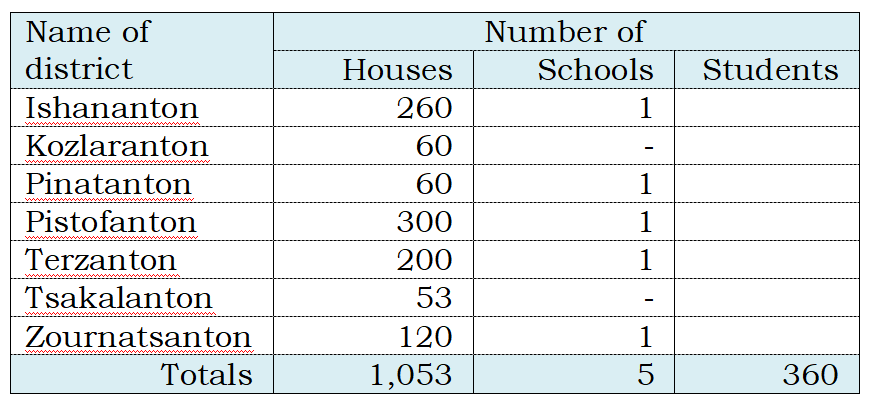
Source: Kiriakidou (1898) in Lazaridis (1968:225).
There were no schools in Santa until 1863, but by the 1911–12 school year, each of the seven main districts of Santa had a school (including a girl’s school at Ishananton) (Bryer 1968:114).
In the past, the Greeks of Santa engaged in a variety of occupations, such as stone masonry, but they also worked as blacksmiths, carpenters and shoemakers. Mining was also an important source of income [until the end of mining in the mid-19th century]. The [silver/] lead and iron mines near Santa were operated by the miners. In addition, [charcoal6] was supplied to the mines at Gümüşhane [and Kromni which stripped the mountains of many trees]. The tiles obtained from the kilns near Zournatsanton district were sold in Trabzon. (Abay 2023:74–75). Due to the climate, growing grain was not possible and so farming was based on vegetables like potatoes, leeks and cabbages for local consumption (http://epontos.blogspot.com/2017/05/blog-post_751.html).
In the 19th century, the inhabitants of Santa, who began to experience economic difficulties, started to emigrate seasonally (Saylan (2016) in Abay 2023:76).7
In this harsh environment, religion was an integral part of life for the Greeks of Santa. A description of the ruined former Greek Orthodox churches in the seven main districts of Santa follows.
Greek Orthodox Churches
Introduction
Santa currently has nine former Greek churches in varying states of decay [due to damage by Turkish treasure hunters, neglect and probably from the severe 1939 Erzincan earthquake (Note 1)], three church bell towers in ruins and 170 residential buildings including some newly built (Abay 2023:83). The bell towers were built either at the same time or soon after the churches were constructed.
The Santa churches were built in the 1860s–1870s and are similar in design. The triple semi-circular apses from the east were an important feature of these churches and nearly all churches had entrances from the south and west. The churches were built with irregular stone masonry of rubble stone, while quality cut stone was used at the corner stones, pillars, window and door jams and decorations around the doors (Bryer 1968:118–120). A description of the Greek churches which are still standing in Santa follows.
Pinatanton
The former Prophet Elias Greek church, (which was used as a stable after the 1923 population exchange between Turkey and Greece) is located in the Pinatanton (Turkish Binatli) district (Fig. 2; Plate 1; Note 2). The church is built of sandstone and is the best preserved church in Santa with its roof in good condition. The four interior columns supporting the arcade and the circular arched high windows rising above the apse wall remain (Plate 2). The original floor was probably removed by [Turkish] treasure hunters8 (Abay 2023:119).
The church is 8.7 m by 12 m with a cross motif in relief on the outer arch of both entrances. Some traces of paintings can be seen on the plaster inside (https://gumushane.ktb.gov.tr/TR-219968/merkez-dumanli-koyu-binatli--pinetendon-mahallesi.html). The renovation of this former church would attract tourists to Santa.
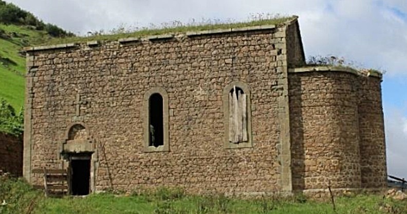
Plate. 1: Prophet Elias Greek church, Pinatanton (Abay 2023:120).
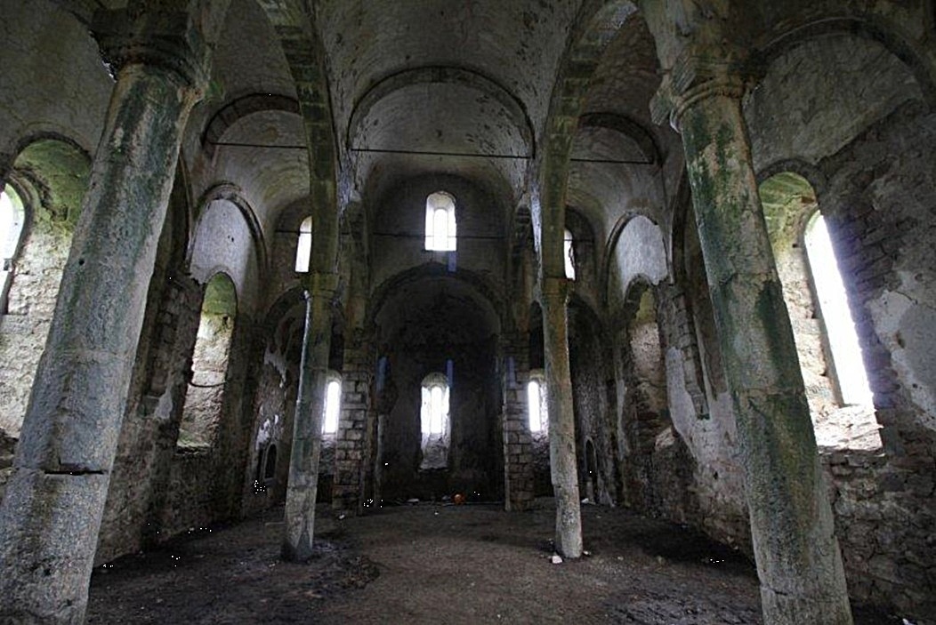
Plate 2: Inside the Prophet Elias Greek church, Pinatanton (Abay 2023:120).
Kozlaranton
The ruined former St Peter Greek church, built of sandstone with its collapsed roof, is located in the Kozlaranton (Turkish Cinganli) district (Plate 3). Its walls are in relatively good condition, but the interior has deteriorated (Abay 2023:121).
Columns were placed on both sides of the south entrance door jamb and a cross motif was engraved on the entrance (https://gumushane.ktb.gov.tr/TR-219969/merkez-dumanli-koyu-cinganli-mahallesi-39kilise39.html).
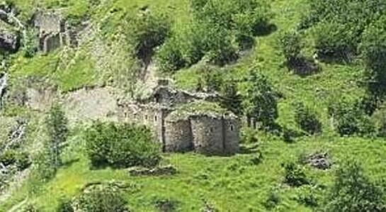
Plate 3: St Peter Greek church, Kozlaranton (https://gumushane.ktb.gov.tr/TR-219969/merkez-dumanli-koyu-cinganli-mahallesi-39kilise39.html).
Tsakalanton
The ruined former Greek Church of the Source of Life with its roof destroyed is located in the Tsakalanton (Turkish Çakali) district (Plate 4). It is 9.9 m by 13.3 m with walls 0.85 m thick. Inside, traces of frescoes are found (https://gumushane.ktb.gov.tr/TR-219970/merkez-dumanli-koyu-cakalli-cakalandon-mahallesi39kilis-.html).
The church was built with [local] soft grey rubble stone. Traces of blue plaster on the frames of the windows and doors can still be seen. The outer walls of the church, which have structural problems, survive due to interventions to prevent it from collapsing9 (Abay 2023:116). The original floor has been destroyed by [Turkish] treasure hunters (Bryer 1968).
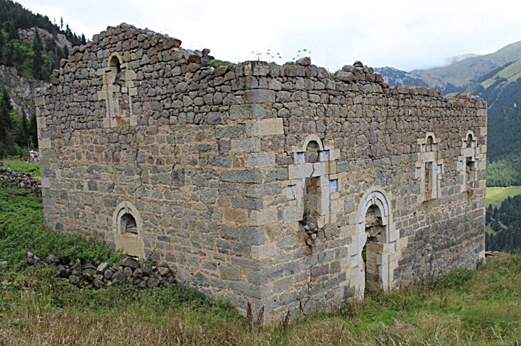
Plate 4: The Greek Church of the Source of Life, Tsakalanton (Abay 2023:117).
Ishananton
The ruined former St Kyriake Greek church with its roof destroyed in the Ishananton (Turkish Işhanli) district (Plate 5) was built with mixture of [local] soft grey stone and sandstone. There are cracks in the walls and some minor repairs were made to prevent further damage. The internal columns and original floor were destroyed (Abay 2023:117).
The church is 10.2 m by 12.5 m with a cross motif and two winged griffins engraved on the outside arch pediment. The main walls are 0.85 m thick rubble stone (https://gumushane.ktb.gov.tr/TR-219971/merkez-dumanli-koyu--ishanli-sihanandon-mahallesi-39kil-.html).
The freestanding bell tower with three floors at the church was made of rubble stone on the interior and cut stone on the exterior (Fig. 3). The remaining base of the tower is in ruins (Abay 2023:127). Sadly, in 1921, the tower was dynamited [probably by the Ottoman army] (Bryer 1968).
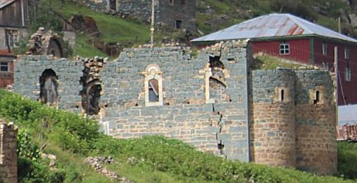
Plate 5: St Kyriake church, Ishananton (Abay 2023:118).
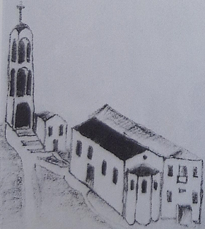
Fig. 3: St Kyriake Greek church, school and bell tower (as they once looked), Ishananton (Angelides (1967) in Bryer (1968:123)).
Pistofanton
In the Pistofanton (Turkish Piştoflu) district, the largest in Santa, two of the three known Greek churches survive.10 The ruined church (exact name unknown), with its roof destroyed, is the smallest in Santa and the only one with a single apse (Plate 6). [Its name could be St Panteleimon, as St Kyriake became a mosque.] The exterior walls are built of soft grey rubble stone and have structural problems (Abay 2023:112–113). A reddish sandstone has also been used in the building of the church (Bryer 1968:122).
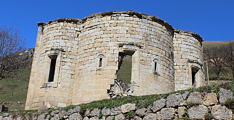
The second church is the ruined former St Christopher Greek church, with its roof destroyed and is the largest church at Santa (Plates 7–9). The church’s three apses are dressed with cut stone. It seems to have been once covered with a dome. The entrances are from the north and the south (Plates 8–9). The north entrance is more elaborate. The frame of the entrance, where a cross shape surmounts the circular arch, is plastered red, yellow and blue (Abay 2023:113–114).
The church was built 17 m by 13 m. On the southern interior of the church, 28 figures of saints in frescoes are depicted (https://gumushane.ktb.gov.tr/TR-219972/merkez-dumanli-koyu--pistov-mahallesi-39st-christoper-k-.html). A bell tower was built adjacent to the church (Fig. 4). The north-west column and the arch remnants connecting the bell tower to the church can be still seen (Plate 9) (Abay 2023:114).
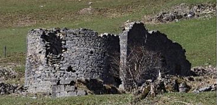
Plate 6: The Greek church at Pistofanton (Abay 2023:113), probably St Panteleimon.
Plate 7: The St Christopher Greek church, Pistofanton (Abay 2023:114).
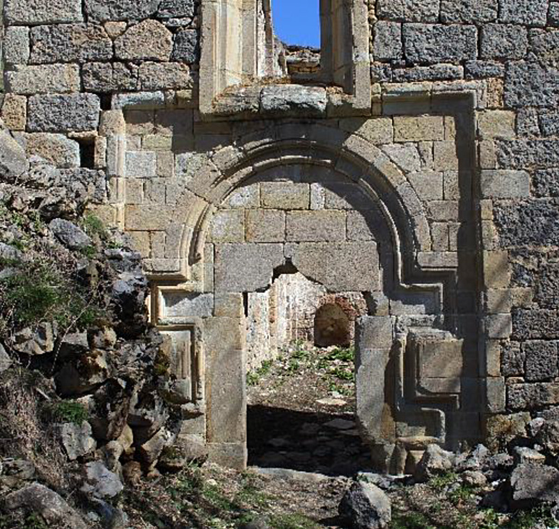
Plate 8: St Christopher Greek church, south entrance, Pistofanton (Abay 2023:115).
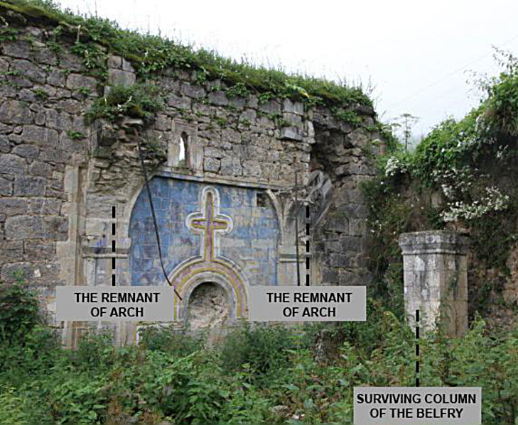
Plate 9: The bell tower ruin at the St Christopher Greek church north entrance, Pistofanton (Abay 2023:126).
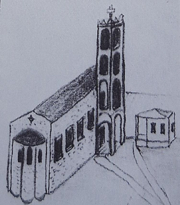
Fig. 4: St Christopher Greek church and bell tower (as they once looked), Pistofanton (Angelides (1967) in Bryer (1968:123)).
The only surviving school with its roof demolished at Santa is located at Pistofanton (Plate 10). The school originally had three floors (Bryer 1968:128).
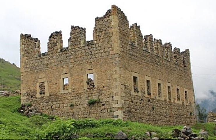
Plate 10: The Greek school, Pistofanton (Abay 2023:129).
Terzanton
This district appears to have grown rapidly from 1857 to 1898 from 80 to 200 houses (Tables 1–2). The ruined former St Theodore Greek church, with its collapsed roof, is located in the Terzanton (Turkish Terzili) district (Plate 11). It was built with a mixture of sandstone and soft grey stone. The west wall leans against the slope. Its internal columns and the original floor were destroyed. The exterior walls survive due to minor intervention (Abay 2023:120–121).
It was built 9.1 m by 11.7 m with two round arched entrances, one in the north and the other in the south (https://gumushane.ktb.gov.tr/TR-219973/merkez-dumanli-koyu-terzili-mahallesi-39st-theodoros-ki-.html). According to Bryer (1968), the church had three layers of plaster over the rough internal stone work.
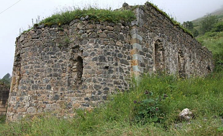
Plate 11: St Theodore Greek church, Terzanton (Abay 2023:121).
There was a bell tower to the south-east of the church. The columns and the arches of the bell tower were built of cut stone, while the vaulted ceiling was made of brick. The exterior of the remaining first floor is in good condition, but the roof is damaged (Plate 12) (Abay 2023:125).
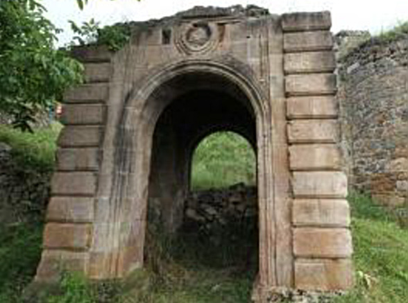
Plate 12: The base of the bell tower, St Theodore Greek church, Terzanton (Abay 2023:128).
Zournatsanton
The ruined former St George Greek church, with its roof destroyed, is the smaller of the two closely located churches in the Zournatsanton (Turkish Zurnaçili) district (Plate 13). The church is built with soft grey stone and had a dome. The walls of the church (whose columns and original floor are destroyed) are in good condition thanks to minor repairs (Abay 2023:122–123).
The main church, the ruined former St Constantine Greek church, with its roof destroyed (Plate 14) was built with soft grey stone. The southern doorway is the most elaborate among all the entrances of the churches at Santa [and as elaborate as the most elaborate in the many churches further south in Chaldia]. The internal columns and original floor have been demolished. The outer walls are in good condition due to minor intervention (Abay 2023:133).
According to Hionides (1996:207) there was a third Greek church, St Kyriake in this district—it has not been found.
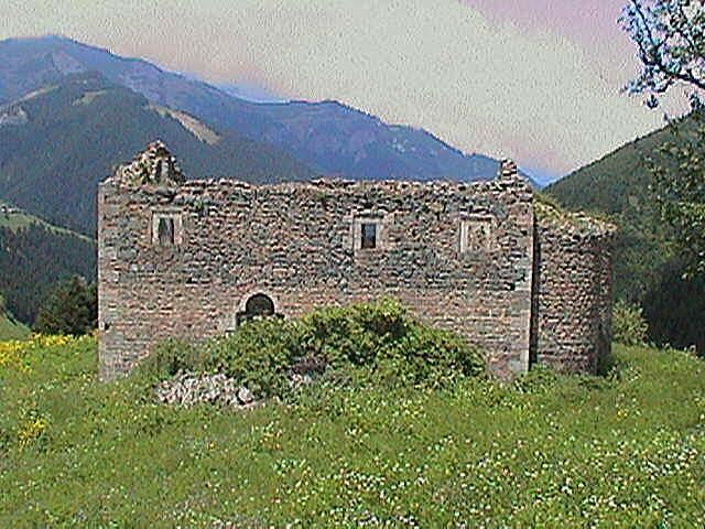
Plate 13: St George Greek church, Zournatsanton (https://gumushane.ktb.gov.tr/TR-219974/merkez-dumanli-koyu-zurnacili-mahallesi-39kilise39.html).
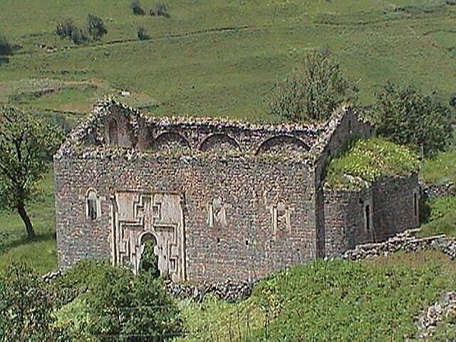
Plate 14: St Constantine Greek church, Zournatsanton (https://gumushane.ktb.gov.tr/TR-219974/merkez-dumanli-koyu-zurnacili-mahallesi-39kilise39.html).
It is hoped that these former churches in Santa can be preserved to ensure Santa’s history. This will also help to attract tourism to the area.
The tragic history of Santa after 1914 with the recent attempts to protect the area will be the subject of a future paper by the author.
Notes
Note 1
Population exchange
The Greek army was defeated in late August 1922, in western Anatolia during the Greco-Turkish War (1919–1922). This exposed the Christian population in Anatolia to retaliation by irregulars and the Turkish army following the atrocities committed earlier by the advancing Greek army (Hirschon 2003b). The Turks then started to force most Greeks out of Anatolia.
The Lausanne Convention signed in January 1923 concerned the terms for the compulsory exchange of Christian and Muslim populations between Greece and Turkey. The exclusion of the Orthodox inhabitants of the Aegean Islands of Imbros and Tenedos, however, was specified in the later Lausanne Treaty (signed in July 1923) (Hirschon 2003a).
Note 2
1939 Erzincan earthquake
The December 1939, 7.8 magnitude earthquake struck Erzincan, Turkey destroying more than 110,000 buildings, claiming 33,000 lives, leaving 100,000 people injured and 250,000 people homeless. It was the deadliest natural disaster in Turkey’s modern history. The catastrophic event impacted on a fifth of the area of Turkey, triggering disturbances 350 km away. As a result, Erzincan needed to be rebuilt at a new location 5.5 km away (Tunc and Tunc 2022).
Acknowledgement
I wish to thank Michael Bennett and Russell McCaskie for their comments to an earlier draft. I am also grateful for Pelin Abay for her recent thesis on Santa.
Footnotes
1. Words within ‘[ ]’ within a reference are the author’s words.
2. Santa was four hours by foot from the Soumela monastery. See the author’s articles on Soumela and Vazelon at: www.pontosworld.com/index.php/history/sam-topalidis/712-the-soumela-monastery-pontos www.pontosworld.com/index.php/history/sam-topalidis/779-st-john-vazelon-monastery-pontos
3. See the author’s articles on traditional costumes and funerals at: www.pontosworld.com/index.php/history/sam-topalidis/736-traditional-pontic-greek-costumes
www.pontosworld.com/index.php/history/sam-topalidis/83-christian-greek-funeral-rituals-in-pontos
4. Crypto-Christians in the Ottoman empire were people who had openly converted from Christianity to Islam, but retained their Christian beliefs and practices in secret (Andreadis 1995).
5. See the author’s article on the Pontic Greek dialect at: www.pontosworld.com/index.php/history/sam-topalidis/688-a-brief-introduction-to-the-pontic-greek-dialect
6. Abay (2023) incorrectly called this coal. The value of the charcoal they delivered was deducted from the taxes of the Santalis.
7. For example, from 1839 to 1861, 72 people from three districts of Santa moved overseas (Abay 2023:76).
8. They were looking for items like hidden church silver or money.
9. This shows that thankfully some Muslims want to maintain historical monuments.
10. Hionides (1996:206) believes that the three churches in Pistofanton were St Kyriake, St Christopher and St Panteleimon.
References
Abay P (2023) An assessment and re-identification of the rural heritage site of Santa (Dumanliköy, Gümüşhane), MSc thesis, Middle East Technical University, Ankara.
Andreadis G (1995) The cryptochristians: klostoi: those who returned, tenesur: those who have changed, Kyriakidis Brothers, Thessaloniki.
Bryer A (1968) ‘Nineteenth-century monuments in the city and vilayet of Trebizond: architectural and historical notes Part 2’, Archeion Pontou (Archive of Pontos) 29:89–129.
Bryer A (1983) ‘The crypto-Christians of the Pontos and consul William Gifford Palgrave of Trebizond’, Theltio Kentrou Mikrasiatikon Spoudon [Bulletin Centre for Asia Minor Studies] Athens, 4:13–68; 363–365.
Bryer A and Winfield D (1985) The Byzantine monuments and topography of the Pontos, I–II, Dumbarton Oaks Research Library and Collection, Harvard University, Washington DC.
Eastern Black Sea Development Agency (2016) Gümüşhane cultural route and tourism discovery guide, Gümüşhane Governor’s Office, Gümüşhane, Turkey.
Hionides C (1996) The Greek Pontians of the Black Sea, Hionides, Boston.
Hirschon R (2003a) ‘Notes on terminology and orthography’, in Hirschon R (ed) (2003c):xi–xiii.
Hirschon R (2003b) ‘‘Unmixing peoples’ in the Aegean region’, in Hirschon R (ed) (2003c):3–12.
Hirschon R (ed) (2003c) Crossing the Aegean: an appraisal of the 1923 compulsory population exchange between Greece and Turkey, Berghahn Books, New York.
Lazaridis D (1988) Στατιστικοι πινακες της εκπαιδεύσεως των Eλληνων στον Ποντο 1821–1922 (in Greek), [Statistical list of Greek schools in the Pontos 1821–1922], Archeion Pontou [Archives of Pontos], sup. 16, Epitropi Pontiakon Meleton, [The Committee for Pontic Studies] Athens.
Tunc TE and Tunc G (2022) ‘Transferring technical knowledge to Turkey: American engineers, scientific experts, and the Erzincan earthquake of 1939’, Notes and Records, 76:387–406.